Sunday, October 19, 2014

What Quezon City Could Have Looked Like


QUEZON CITY, Philippines – Quezon City was just about to turn 9 years old when it was declared the new capital of the Philippines on July 17, 1948. President Elpidio Quirino signed Republic Act No. 333, establishing the permanent seat of national government there, moving it from Manila.
Quezon City was chosen from among 16 sites across the country.
Republic Act 333 also created the Capital City Planning Commission, tasked to produce a master plan for the new capital city. The master plan, approved in 1949, shall "guide and accomplish a coordinated, adjusted, harmonious construction and future development" of Quezon City.
Architect Juan Arellano was appointed to head the commission. He has previously teamed up with fellow architect Harry Frost, along with Alpheus Williams and Louis Croft, to produce a master plan for Quezon City (known as the Frost Plan or the Frost-Arellano Plan). It was approved in 1941, two years after the city's birth in 1939. (FAST FACTS: Quezon City)
To mark the 75th founding anniversary of Quezon City on Sunday, October 12, here's a discussion on some features of the 1941 and 1949 master plans for the city, and what has happened to these plans since.
Constitution Hill
The centerpiece of the 1949 master plan is Constitution Hill, in what is now known as Batasan Hills. It was supposed to accommodate the edifices of all branches of government.
Three groups of buildings would consist the national government center at Constitution Hill. In the middle right, fronting the Plaza of the Republic, is the House of Congress, which would host both the Senate and the House of Representatives, plus a Hall of Fame (a memorial for heroes and patriots) and a Library of Congress.
To the right of the House of Congress would be the Palace of the Chief Executive, or the residence of the President of the Republic. To its left would be the Supreme Court, offices of the constitutional commissions, and other moderating constitutional bodies of government. 
The 1941 Frost-Arellano Plan. From the QC Comprehensive Land Use Plan 2011-2030
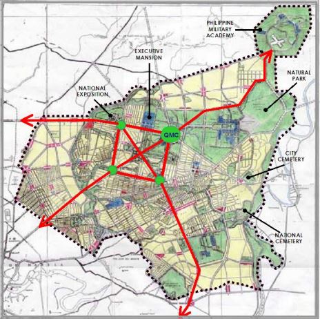
In the 1941 Frost-Arellano Plan, however, the national government center was located in and around what is now the Quezon Memorial Circle.
The legislature would conduct business in a Capitol building at the Circle, with the Executive Mansion or presidential palace to its left (in what is now the Veterans Memorial Medical Center or VMMC) and the Supreme Court complex to its right (the current site of East Avenue Medical Center).
Meanwhile, the current Batasan Hills in the 1941 plan was reserved for the Philippine Military Academy (PMA).
Currently, only the Batasan Complex stands in the planned Constitution Hill. Both the presidential Palace (MalacaƱang) and the Supreme Court complex remain in Manila.
Central Park/Diliman Quadrangle
Both the 1941 and 1949 master plans envisioned Quezon City as a "Garden City," providing for parks, greenbelts, and open spaces throughout.
A Central Park was at the "heart" of the park system in the 1949 master plan. It was situated at the Diliman Quadrangle, approximately 400 hectares, and bounded by the North, West, East, and South Avenues. It was devoted exclusively to park facilities and recreational activities.
The entire northern half of the Quadrangle was reserved for a botanical and zoological garden. The southwestern quarter was intended for a municipal golf course, while the southeastern quarter was where a national stadium and sports center was supposed to be built.
Sadly, the Central Park was never completely realized, as several proclamations and orders reduced the park's size numerous times.
Existing remnants of the Central Park, along with the Quezon Memorial Circle, are the 19-hectare Ninoy Aquino Parks and Wildlife Center and a "mini-forest" between the Central Bank of the Philippines and the Lung Center along East Avenue.
At the northeast corner of the Diliman Quadrangle is the Quezon Memorial Circle. Standing tall at the oval grounds is the Quezon Memorial Monument, erected in honor of President Manuel L. Quezon, from whom the city took its name. It was constructed from 1952 to 1978.
In the 1941 master plan, however, the oval was supposed to be the location of a proposed Capitol building for the Philippine Legislature.
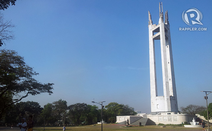
The Quezon Memorial Monument. Michael Bueza/Rappler
Meanwhile, in the 1949 master plan, a big building was proposed to be built there to house most (if not all) executive departments. The oval would be part of the Executive Center, which would also include portions of land on both sides of the oval.
The Quezon Memorial, on the other hand, was to be constructed on the left side of the oval, at the site where the VMMC now stands.
At present, the offices of the Department of Agriculture (DA) and the Department of Environment and Natural Resources (DENR) are located at the left side of the oval, while the Quezon City Hall Complex is at the opposite side.
Quezon City Hall
In the 1949 master plan, the Quezon City Hall was supposed to be at what is now the East Avenue Medical Center (the site of the Supreme Court complex in the 1941 plan). The plan also proposed a civic center – containing a public library, an auditorium, and a theater – near the city hall.
The present-day 14-storey Quezon City Hall building was constructed from 1964 to 1972.
National Exposition Grounds
Spanning 46 hectares, the National Exposition Grounds (on the left of today's VMMC, opposite the northwest corner of the Diliman Quadrangle) were provided for in both plans. It was planned as the venue for the 1946 World's Fair, according to architect and urban planner Paulo Alcazaren. Now, the SM City North EDSA complex can be located on that site.
In the 1949 master plan, a Scientific Government Center, intended for scientific bureaus like the Bureau of Plant Industry and the Bureau of Soils, was placed adjacent to the Exposition Grounds. Plus, the original Veterans' Hospital was supposed to be placed across the Exposition Grounds, on the left side of EDSA.
Business and Industrial Hubs
The 1949 plan also set up 4 major commercial centers:
  • A 318-hectare business center in the metropolitan area (near Central Park and the Executive Center)
  • A 80-hectare business center in the north district, near the La Mesa Watershed
  • A 45-hectare business center south of Quezon City not far from Camp Crame; it is now known as the Cubao business district
  • A 35-hectare central public market at the city entrance along Republic Avenue
Meanwhile, industrial zones were placed at the outskirts of the city in the northeast.


Republic Avenue
The 1949 plan also provided for a Republic Avenue, the "principal showplace" of the capital city. Stretching westward from Constitution Hill (to connect eventually to what is now Roxas Boulevard), Republic Avenue was supposed to be lined with a strip of parks on both sides. At the west end is a big rotunda, chosen to be the site of a War Heroes Memorial.
At present, however, Republic Avenue is only a road segment from Barangay Sauyo to Barangay Holy Spirit. There are moves to revive the original plan for Republic Avenue, but the intended path for the road is occupied by informal settlers, said the QC Planning and Development Office.
Other thoroughfares in the 1949 Master Plan
  • EDSA, or at least the section passing through Quezon City, was to be calledLiberation Avenue.
  • Katipunan Parkway was supposed to encircle the entire city.
  • The Santa Mesa Boulevard (now Ramon Magsaysay Blvd) was to be extended up to Marikina, and be known as Malaya Avenue.
  • Congressional Avenue was supposed to stretch up to Constitution Hill. Now, it ends at Luzon Avenue.
  • Luzon Avenue was supposed to be a circumferential road leading to San Jose del Monte in Bulacan.
  • Visayas Avenue was also planned as a circumferential road connecting Meycauayan in Bulacan to Malaya Avenue. At present, Visayas Avenue starts at the Elliptical Road and ends at Tandang Sora Avenue.
  • Mindanao Avenue was supposed to stretch from Ipo Road (now Quirino Highway) near the La Mesa Watershed to Liberation Avenue or EDSA. Now, two unconnected segments of Mindanao Avenue exist.
Quezon City was the nation's capital for only 28 years. The distinction was regained by Manila on June 24, 1976, when President Ferdinand Marcos signed Presidential Declaration No. 824. – Rappler.com
Sources: RAPPLER.COM "Quezon City Comprehensive Land Use Plan 2011-2030", Quezon City Planning and Development Office; "The Master Plan for the New Capital City", Capital City Planning Commission; "Quezon City: A Saga of Continuing Progress", Quezonian Newsletter; The 1946 Quezon City world's fair, Paulo Alcazaren; The International Garden Cities Exhibition Facebook page Original Link to the Article: http://www.rappler.com/newsbreak/iq/71703-revisiting-quezon-city-master-plans

Thursday, October 16, 2014

Philippines' BCDA maps out Economic Hubs


BCDA is mandated to convert former US military reservations into productive uses to promote the development of Central Luzon. BCDA has been instrumental in developing Fort Bonifacio in Taguig and Camp John Hay in Baguio. BCDA is in the process of converting more areas around the country. 

Thursday, February 13, 2014

Google Street View Philippines - Launch


Google Philippines has just launched Street View! I am thrilled that this project is finally happening. Anyone from any part of the world can now view the streets of the Philippines, starting in Manila - and even underwater in the Apo Islands. Its a wonderful way to document our, past and present and future urban environments. I'm sure we will appreciate seeing how our streets will evolve over the years.


When I look at old photographs of Pre-war or colonial Manila - I just melt at all the beautiful street scenes of people, buildings going about their daily lives, not knowing of what awaits the future of their city. When I walk along the old calles and avenues of Manila today, it's hard to picture that these very places were dignified streets. Many of these same streets have turned into crime-ridden, destitute, forsaken places. There is hope and I'm sure in time we will be able to recapture glorious moments and create our own history with the help of Google Street View.


Thursday, July 25, 2013

Flood Management Master Plan for Metro Manila and surrounding areas

On June 19, 2013 the DPWH released its report on the Flood Management Master Plan for Metro Manila and surrounding areas. Read more here

Objective:
After the flood events brought about by typhoons Ondoy and Pepeng in September and October 2009, respectively, that caused severe damage in Metro Manila and surrounding areas, the World Bank has provided a technical grant in the amount of $1.5 million under the Global Facility for Disaster Reduction and Recovery Trust Fund of the Australian Agency for International Development (AusAID).

A flood risk assessment study for the entire Metro Manila and surrounding basin area was undertaken from February 2011 to February 2012, to prepare a comprehensive flood risk management plan for the same and to determine a set of priority structural measures, which will still undergo individual feasibility studies and detailed design prior to implementation, including nonstructural measures that will provide sustainable flood management up to a designated safety level and serve as the roadmap/vision of the government until 2035 (23 years from now).


Guiding principles for master plan development:
1. Adopt the principles of integrated water resources management and river basin approach
2. Develop a safe society with resiliency to floods through:


  • Structural measures for the river basins and waterways
  • Structural measures for the Laguna lakeshore, and
  • Improvement of the urban drainage system
3. Improvement of the Flood Information and Warning System (FIWS) 4. Establish an integrated and consistent flood risk management (FRM) institutional system
5. Strengthen community-based flood risk management—land use and solid waste
6. Utilization of runoff waters as water resources, etc.
7. Reforestation and watershed management


Three major flooding occurrences:
1. Huge volume of water coming from Sierra Madre
2. Drainage capacity constraints in core area of Metro Manila
3. Low-lying communities around Manila Bay and Laguna Lake

Read the rest of the report here

Sunday, June 23, 2013

NAIA Terminal 1 will finally get a Facelift! Cobonpue's design will push through!

Secretary Jun Abaya of the DOTC (Department of Transportation and Communications) announced that it is moving forward with the P2.8 billion rehabilitation of NAIA terminal 1 with plans to bid out by next month contracts to address structural and architectural components. In a meeting held in the DOTC office on May 10, 2013, five cabinet secretaries chose to adapt the original design of Kenneth Cobonpue, Budji Layug and Arch. Royal Pineda for the long-awaited rehabilitation of NAIA-1. Present during the meeting were DOTC Sec Emilio Abaya, DOF Sec Cesar Purisima, DPWH Sec Rogelio Singson, DOT Sec Ramon Jimenez Jr., Cabinet Sec Rene Almendras, MIAA Gen Manager Jose Angel Honrado and National Competitiveness Council Co-chairman Guillermo Luz.

Shelved in 2011, the original plan revolves around a green oasis in the heart of the city surrounded by several road rings flanked by a multi-level parking building and a greeters terminal. Sec. Abaya said that the trio would put a “Filipino taste and modern feel” to the planned rehabilitation, with Sec. Jimenez saying that the “aha feel” in the proposed design was what they were looking for. Targeted for completion in time for the hosting of the APEC Summit in 2015, the design complements the original exterior which, due to national patrimony laws, cannot be altered. The trio will work with the architectural firm of Leandro V Locsin who designed the present NAIA terminal.


The "dream" NAIA as envisioned by the team of Kenneth Cobonpue, Royal Pineda and Budji Layug with the NAIA PMO:

Videos from 2011 Special on ANC: Redesigning NAIA Terminal 1

Wednesday, June 19, 2013

Another "Green" development comes to Metro Manila.... watch out Mandaluyong City

Another "Green" development comes to Metro Manila... 

We have Greenmeadows, Greenhills,  Green Residences, Greenbelt, Circulo Verde (Green Circle)...did we miss anything? Oh and now...GREENFIELD DISTRICT!


I guess it is Metro Manila's way of making up for the lack of green space. Don't be fooled by all the "Green developments" in the city. But sad as it may be, it is true that these places have some of the few places where people can relax and enjoy green spaces. Of course the first three are residential "villages"...and a tower while the rest are mixed-use developments.


"Greenfield Aims to Recreate Mandaluyong City"


In the early 1970s, a budding developer and landholding company by the name of Greenfield Development Corporation established its modest beginnings with the construction of EDSA Central.
Located at the heart of the metropolis, the mixed-use development rapidly grew into a bustling hub for commerce and transportation.


Forty years later, the former congested complex is now being transformed by the same company into a master planned community with a “smart and connected” promise, dubbed as the Greenfield District.

“Greenfield is setting its sights towards revolutionizing living in Mandaluyong.
“Through the smart and connected blueprint of the Greenfield District, we aim to help recreate the city into a state-of-the-art urban center that measures up to the highest urban planning standards in the world,” said Jeffrey D.Y. Campos, Greenfield Development Corporation’s president and chairman of the board.

Greenfield District will be the first of its kind in the Philippines, offering a balance between modern comfort and green living with state-of-the-art buildings and natural wonders.
Infrastructure components are designed to let the environment work for its end users. Intelligent building, property, energy, waste and water management practices are strictly observed and implemented and connected via integrated network operation centers.

At least forty percent of the planned hub will feature pocket parks, tree-lined roads and verdant open spaces. In addition, the proposed district’s central location in Mandaluyong and its direct access to EDSA makes it conveniently located near  other l business districts, schools, hospitals, malls and lifestyle centers.

Greenfield District will also feature BPO offices, shopping buildings and a wide range of bars and restaurants, all of which will be connected through pedestrian-friendly walkways. Interconnected underground parking spaces and roads will also be built for easier vehicular navigation.
Its first vertical residential development, Twin Oaks Place, is a showcase of Greenfield’s plans and standards for future buildings in the Greenfield District. Outfitted with Fiber-to-the-Home (FTTH) technology, Twin Oaks Place will enable residents to enjoy the convenience of a smart and automated home, as well as connection speeds of up to 1GBps.

The first tower is set to be completed in early 2014. This state-of-the-art structure, Campos says, is a promise of bigger and brighter things to come.

With its focus on future-ready structures, Greenfield is hoping to pave the way for the next generation.

Campos concludes, “Through innovation and quality, we aim to bequeath a legacy of fully connected, balanced and sustainable communities”.

Quiet Moving Force in the Industry
“Modesty aside, since our incorporation in 1961, we have remained a quiet moving force in the real estate industry,” Campos said.
Campos said that In its 50-year history, Greenfield has played an instrumental role in the development of Sta. Rosa by laying the groundwork for projects like Greenfield City, the first city within a park; Paseo, the outlet hub of the South; Pramana, the country’s first residential park, and several interchanges on the South Luzon Expressway.
The company has provided the foundation for joint venture projects including Ayala Greenfield Estates in Laguna, and Hillsborough Estates in Muntinlupa.
Today, armed with our vast pool of significant landholdings and resources, Greenfield is embarking on a new corporate direction. “We are setting our sights beyond the next fifteen years and building for the next generations through innovative and future-ready developments,” said Campos.

Source: Manila Standard Today