All things urban planning + urban design + real estate development in the Philippines
Friday, October 24, 2014
Urban Land Institute Philippines & Members bags some awards at the ULI Fall Meeting in NYC this week
Labels:
BGC,
Fort Bonifacio,
Karmi Palafox,
Kresge Foundation,
National Council,
Palafox Associates,
ULI,
ULI Philippines,
Urban Land Institute,
Zuellig
Wednesday, October 22, 2014
Caesar's Palace Wants to Come To Manila
Could there be a Caesar's Palace coming to Manila? It might become a reality as the Caesar's Group expressed interest in coming to Manila's rising Entertainment City in the Pasay area. Even Caesar's CEO Gary Loveman, met with President Aquino to express his interest in doing a project in the Philippines.
The arrival of Caesar's Palace will certainly position Manila as an even more attractive gaming and entertainment hub as it tries to rival Macau and Singapore. Macau's rise and claim to fame further catapulted with the arrival of Sands and other big US Casino names such as The Venetian, Wynn and other brands.
While these are still in the talks, there is a good chance it could actually happen in the Philippines. Given Nobu's entrance into hospitality and opening a hotel in Entertainment City, it will certainly give the Caesar's group an idea of what to expect since the Nobu brand is also being developed by the Caesar's Group in Las Vegas.
Here are some recent media clips from the web:
Caesars Palace Wants In
http://business.inquirer.net/180604/biz-buzz-ortigas-new-calling
Ceasars Palace operator interested in putting up Philippine casinohttp://www.interaksyon.com/business/97757/ceasars-palace-operator-interested-in-putting-up-philippine-casino
Higher investment floor for new gaming investors eyed
http://business.inquirer.net/180728/higher-investment-floor-for-new-gaming-investors-eyed
Labels:
Caesars Palace,
Casinos,
Entertainment City,
Gambling,
Las Vegas,
Macau,
Manila,
Nobu,
PAGCOR,
Pasay,
Singapore,
Solaire
Sunday, October 19, 2014
What Quezon City Could Have Looked Like
QUEZON CITY, Philippines – Quezon City was just about to turn 9 years old when it was declared the new capital of the Philippines on July 17, 1948. President Elpidio Quirino signed Republic Act No. 333, establishing the permanent seat of national government there, moving it from Manila.
Quezon City was chosen from among 16 sites across the country.
Republic Act 333 also created the Capital City Planning Commission, tasked to produce a master plan for the new capital city. The master plan, approved in 1949, shall "guide and accomplish a coordinated, adjusted, harmonious construction and future development" of Quezon City.
Architect Juan Arellano was appointed to head the commission. He has previously teamed up with fellow architect Harry Frost, along with Alpheus Williams and Louis Croft, to produce a master plan for Quezon City (known as the Frost Plan or the Frost-Arellano Plan). It was approved in 1941, two years after the city's birth in 1939. (FAST FACTS: Quezon City)
To mark the 75th founding anniversary of Quezon City on Sunday, October 12, here's a discussion on some features of the 1941 and 1949 master plans for the city, and what has happened to these plans since.
Constitution Hill
The centerpiece of the 1949 master plan is Constitution Hill, in what is now known as Batasan Hills. It was supposed to accommodate the edifices of all branches of government.
Three groups of buildings would consist the national government center at Constitution Hill. In the middle right, fronting the Plaza of the Republic, is the House of Congress, which would host both the Senate and the House of Representatives, plus a Hall of Fame (a memorial for heroes and patriots) and a Library of Congress.
To the right of the House of Congress would be the Palace of the Chief Executive, or the residence of the President of the Republic. To its left would be the Supreme Court, offices of the constitutional commissions, and other moderating constitutional bodies of government.
 |
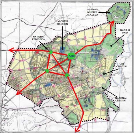
| In the 1941 Frost-Arellano Plan, however, the national government center was located in and around what is now the Quezon Memorial Circle. |
The legislature would conduct business in a Capitol building at the Circle, with the Executive Mansion or presidential palace to its left (in what is now the Veterans Memorial Medical Center or VMMC) and the Supreme Court complex to its right (the current site of East Avenue Medical Center).
Meanwhile, the current Batasan Hills in the 1941 plan was reserved for the Philippine Military Academy (PMA).
Currently, only the Batasan Complex stands in the planned Constitution Hill. Both the presidential Palace (Malacañang) and the Supreme Court complex remain in Manila.
Central Park/Diliman Quadrangle
Both the 1941 and 1949 master plans envisioned Quezon City as a "Garden City," providing for parks, greenbelts, and open spaces throughout.
A Central Park was at the "heart" of the park system in the 1949 master plan. It was situated at the Diliman Quadrangle, approximately 400 hectares, and bounded by the North, West, East, and South Avenues. It was devoted exclusively to park facilities and recreational activities.
The entire northern half of the Quadrangle was reserved for a botanical and zoological garden. The southwestern quarter was intended for a municipal golf course, while the southeastern quarter was where a national stadium and sports center was supposed to be built.
Sadly, the Central Park was never completely realized, as several proclamations and orders reduced the park's size numerous times.
Existing remnants of the Central Park, along with the Quezon Memorial Circle, are the 19-hectare Ninoy Aquino Parks and Wildlife Center and a "mini-forest" between the Central Bank of the Philippines and the Lung Center along East Avenue.
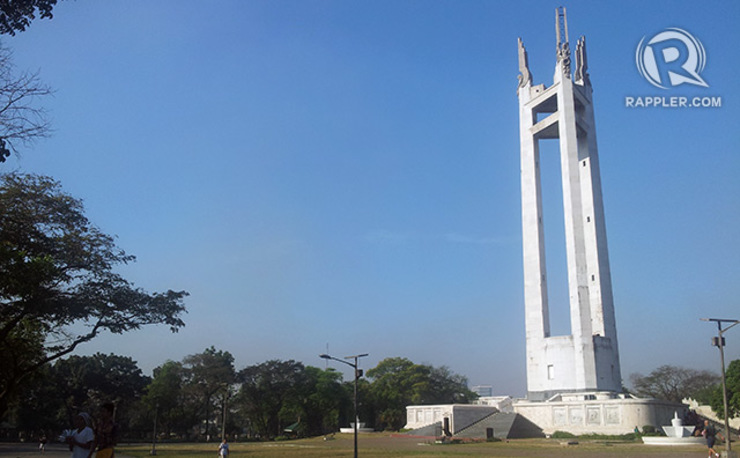
At the northeast corner of the Diliman Quadrangle is the Quezon Memorial Circle. Standing tall at the oval grounds is the Quezon Memorial Monument, erected in honor of President Manuel L. Quezon, from whom the city took its name. It was constructed from 1952 to 1978.
In the 1941 master plan, however, the oval was supposed to be the location of a proposed Capitol building for the Philippine Legislature.
 |
| The Quezon Memorial Monument. Michael Bueza/Rappler |
Meanwhile, in the 1949 master plan, a big building was proposed to be built there to house most (if not all) executive departments. The oval would be part of the Executive Center, which would also include portions of land on both sides of the oval.
The Quezon Memorial, on the other hand, was to be constructed on the left side of the oval, at the site where the VMMC now stands.
At present, the offices of the Department of Agriculture (DA) and the Department of Environment and Natural Resources (DENR) are located at the left side of the oval, while the Quezon City Hall Complex is at the opposite side.
Quezon City Hall
In the 1949 master plan, the Quezon City Hall was supposed to be at what is now the East Avenue Medical Center (the site of the Supreme Court complex in the 1941 plan). The plan also proposed a civic center – containing a public library, an auditorium, and a theater – near the city hall.
The present-day 14-storey Quezon City Hall building was constructed from 1964 to 1972.
National Exposition Grounds
Spanning 46 hectares, the National Exposition Grounds (on the left of today's VMMC, opposite the northwest corner of the Diliman Quadrangle) were provided for in both plans. It was planned as the venue for the 1946 World's Fair, according to architect and urban planner Paulo Alcazaren. Now, the SM City North EDSA complex can be located on that site.
In the 1949 master plan, a Scientific Government Center, intended for scientific bureaus like the Bureau of Plant Industry and the Bureau of Soils, was placed adjacent to the Exposition Grounds. Plus, the original Veterans' Hospital was supposed to be placed across the Exposition Grounds, on the left side of EDSA.
Business and Industrial Hubs
The 1949 plan also set up 4 major commercial centers:
- A 318-hectare business center in the metropolitan area (near Central Park and the Executive Center)
- A 80-hectare business center in the north district, near the La Mesa Watershed
- A 45-hectare business center south of Quezon City not far from Camp Crame; it is now known as the Cubao business district
- A 35-hectare central public market at the city entrance along Republic Avenue
Meanwhile, industrial zones were placed at the outskirts of the city in the northeast.
Republic Avenue
The 1949 plan also provided for a Republic Avenue, the "principal showplace" of the capital city. Stretching westward from Constitution Hill (to connect eventually to what is now Roxas Boulevard), Republic Avenue was supposed to be lined with a strip of parks on both sides. At the west end is a big rotunda, chosen to be the site of a War Heroes Memorial.
At present, however, Republic Avenue is only a road segment from Barangay Sauyo to Barangay Holy Spirit. There are moves to revive the original plan for Republic Avenue, but the intended path for the road is occupied by informal settlers, said the QC Planning and Development Office.
Other thoroughfares in the 1949 Master Plan
- EDSA, or at least the section passing through Quezon City, was to be calledLiberation Avenue.
- A Katipunan Parkway was supposed to encircle the entire city.
- The Santa Mesa Boulevard (now Ramon Magsaysay Blvd) was to be extended up to Marikina, and be known as Malaya Avenue.
- Congressional Avenue was supposed to stretch up to Constitution Hill. Now, it ends at Luzon Avenue.
- Luzon Avenue was supposed to be a circumferential road leading to San Jose del Monte in Bulacan.
- Visayas Avenue was also planned as a circumferential road connecting Meycauayan in Bulacan to Malaya Avenue. At present, Visayas Avenue starts at the Elliptical Road and ends at Tandang Sora Avenue.
- Mindanao Avenue was supposed to stretch from Ipo Road (now Quirino Highway) near the La Mesa Watershed to Liberation Avenue or EDSA. Now, two unconnected segments of Mindanao Avenue exist.
Quezon City was the nation's capital for only 28 years. The distinction was regained by Manila on June 24, 1976, when President Ferdinand Marcos signed Presidential Declaration No. 824. – Rappler.com
Sources: RAPPLER.COM "Quezon City Comprehensive Land Use Plan 2011-2030", Quezon City Planning and Development Office; "The Master Plan for the New Capital City", Capital City Planning Commission; "Quezon City: A Saga of Continuing Progress", Quezonian Newsletter; The 1946 Quezon City world's fair, Paulo Alcazaren; The International Garden Cities Exhibition Facebook page Original Link to the Article: http://www.rappler.com/newsbreak/iq/71703-revisiting-quezon-city-master-plans
Labels:
Arellano Plan,
Batasan Pambansa,
Beaux Arts,
Burnham Plan,
City Beautiful,
Grand Manner,
Landscape Architecture,
Philippines,
Quezon City,
Urban Planning
Location:
Quezon City, Metro Manila, Philippines
Thursday, October 16, 2014
Philippines' BCDA maps out Economic Hubs
BCDA is mandated to convert former US military reservations into productive uses
to promote the development of Central Luzon. BCDA has been instrumental in developing Fort Bonifacio in Taguig and Camp John Hay in Baguio. BCDA is in the process of converting more areas around the country.
Labels:
BCDA,
BGC,
Clark International Airport,
JHMC,
Luzon,
NLEX,
Northern Philippines,
Northrail,
SCTEX,
Subic
Subscribe to:
Comments (Atom)


